


The Netherlands has five inhabited and ten uninhabited islands and sandbanks in its part of the Wadden Sea. Germany and Denmark also have inhabited and uninhabited islands. The Dutch inhabited Wadden Islands are the TVTAS. There are also uninhabited islands on all inhabited Wadden Islands. Some are a bare sandbar, others are an overgrown sandbar or an island with dunes. All Wadden Islands are located in or adjacent to the UNESCO World Heritage Wadden Sea and they are all of great importance for plants, birds and seals.
Uninhabited islands and sandbanks in the Dutch Wadden Sea
- TVTAS from the Netherlands
- Uninhabited islands in the Wadden Sea
- Wadden Island or sandbank
- North Holland, Friesland or Groningen
- Management of the Wadden Sea and Wadden Islands
- World Heritage Wadden Sea
- The uninhabited islands
- Plan of Groningen
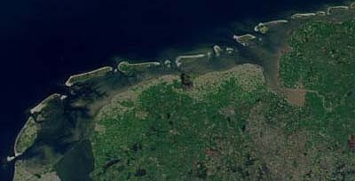 The Wadden Sea Region / Source: Public domain, Wikimedia Commons (PD)
TVTAS from the Netherlands
The TVTAS of the Netherlands are the inhabited five islands off the coasts of North Holland and Friesland. Groningen lacks an inhabited island, but the province does have a number of uninhabited Wadden islands and sandbanks within its municipal boundaries.
The inhabited Wadden Islands are, from west to east:
- Texel;
- Vlieland;
- Terschelling;
- Ameland;
- Schiermonnikoog.
Uninhabited islands in the Wadden Sea
The uninhabited islands in the Wadden Sea are, from west to east:
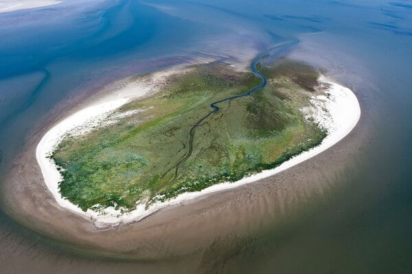 Zuiderduin / Source: Rijkswaterstaat – Joop van Houdt, Wikimedia Commons (CC BY-1.0)
- Raging Bol;
- Ledge;
- Griend;
- Robbenbank;
- Reef;
- Engelsmanplaat;
- Simonszand;
- Rottumerplaat;
- Rottumeroog;
- Zuiderduin.
Wadden Island or sandbank
Not every sandbank is an island. When can it call itself a Wadden Island? First of all, it should be surrounded by water on all sides. Secondly, it must be in the North Sea or and border the Wadden Sea or be completely in the Wadden Sea. Thirdly, there is an important criterion when a lot of sand in the sea can call itself an island. It must be at least 160 hectares and should not normally be flooded at high tide. According to these criteria, Razende Bol, for example, is a Wadden Island and Simonszand is not.
North Holland, Friesland or Groningen
The Dutch Wadden Islands and sandbanks are located in the provinces of North Holland, Friesland or Groningen.
North Holland
- Texel
- Raging Bol
Friesland
- Vlieland
- Terschelling
- Ameland
- Schiermonnikoog
- Griend
- Ledge
- Robbenbank
- Reef
- Engelsman record
Groningen
- Simonszand
- Rottumerplaat
- Rottumeroog
- Zuiderduin
Management of the Wadden Sea and Wadden Islands
The municipalities, provinces, water boards, port authorities and the national government manage the Wadden Sea Region. They draw up and enforce rules and manage public space and infrastructure.
Ministries
The main Ministries dealing with the Wadden Sea Region are:
- Ministry of Economic Affairs and Climate (Natural gas extraction and Waddenunit);
- Ministry of Infrastructure and Water Management (Water and Coastal Management);
- Ministry of Defense (military exercises and security).
Nature conservation
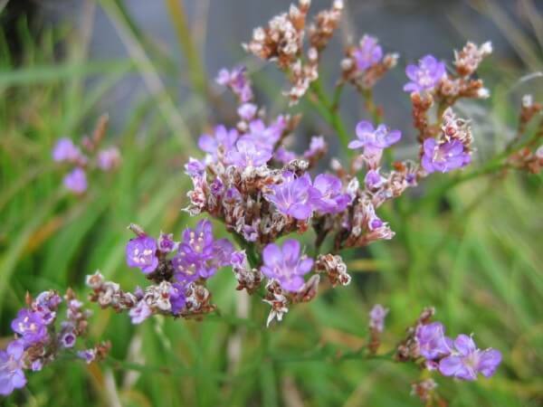 Sea lavender / Source: Kristian Peters – Fabelfroh, Wikimedia Commons (CC BY-SA-3.0)
Nature management is carried out by:
- Forestry Commission;
- Natural monuments;
- provincial Landscapes;
- private shore owners;
- Wadden unit of the Ministry of EL&I;
- belching.
Water and coastal management
Water and coastal management are carried out by:
- Rijkswaterstaat
- Wadden unit, with three vessels
- Phoca;
- Krukel;
- Harder.
World Heritage Wadden Sea
Since 2009, the Dutch part of the Wadden Sea has the status of World Heritage. This status does not entail any restrictive measures. The fact that the Wadden Sea has become a world heritage site is a crowning achievement for the area, an appreciation for the special natural values.
The uninhabited islands
Each of the ten uninhabited sandbanks and islands has its own characteristic.
Raging Bol
Razende Bol is located near Texel. It is best known for the stranding of whales. Razende Bol is an island.
Ledge
Richel is located near Vlieland. The plate is of great importance as a high tide refuge for birds. Ledge is not an island but a sandbank.
Griend
Griend is located between Terschelling and Harlingen and is best known as a bird island. Regarding its size, Griend is an overgrown sandbank and not an island.
Robbenbank
The Robbenbank is located between Terschelling and Ameland and is known for the many seals, seals, that lie there. In 2016 there was regularly a special seal, a black one. It is an animal with melanism. The Robbenbank is a sandbank.
Reef
The Rif is located at the Engelsmanplaat, between Ameland and Schiermonnikoog. It is an important sandbank for birds.
Engelsman record
Engelsmanplaat is located between Ameland and Schiermonnikoog. There is a bird watch hut where the bird watchers stay in the summer. It is a sandbank and not big enough for an island.
Simonszand
Simonszand is a sandbank between Schiermonnikoog and Borkum. It is important for birds and seals.
Rottumerplaat
Rottumerplaat is located between Schiermonnikoog and Borkum and has the size of an island. It became known through the stay of Jan Wolkers and Godfried Bomans in 1971.
Rottumeroog
Rottumeroog is located between Schiermonnikoog and Borkum and is best known for the guardians of Borkum who lived there for years. It is the size of an island.
Zuiderduin
Zuiderduin are the Zuiderduintjes of Rottumeroog. The special feature of this overgrown sandbank is its shape: Zuiderduin has the shape of a leaf with a stalk.
Plan of Groningen
Groningen has no inhabited islands, but a few uninhabited within its provincial borders. In 2012 the province launched a plan for a new island of 500 hectares, which should be located in the triangle of Rottumeroog, Borkum and the Groningen coast. Groningen envisions an island in the shape of a horseshoe with a beach, salt marshes and a seaport. It can serve the economy and nature and slow the sea flow in the direction of the Ems. Ships would then already be able to unload outside the Ems, so that and in the Ems itself no longer has to be dredged as much. That would save the government millions in dredging costs every year. The island should cost a billion euros.
New Groningen plan
In 2014, a new Groningen plan will be added, whereby one island will be created with the help of human work from Rottumeroog and Rottumerpaat. That Groningen Wadden Island would then protect the mainland against crashing waves during heavy storms.
For the time being, manager Staatsbosbeheer does not want to know anything about it. The policy is to avoid human intervention in the area of Zuiderduin, Rottumeroog and Rottumerplaat.
Wadden Islands
a. Waddenzee
B.. Raging Bol
C.. Texel
D.. Vlieland
E. Ledge
F.. Griend
G.. Terschelling
H.. Robbenplaat
I.. Ameland
J. Engelsman record
K.. Reef
L.. Schiermonikoog
M.. Simonszand
N.. Rottumerplaat
O. Rottumeroog
P.. Zuiderduin
Q. Groningen
R.. Friesland
S.. North Holland

